Use APKPure App
Get 快測ナビ old version APK for Android
Free navigation is a construction terminal application that is equipped with a “navigation anywhere” function that makes full use of 3D data and CAD.
Kaisoku Navi is a construction terminal app that allows you to navigate high-quality, highly efficient smart construction at construction sites! It is equipped with a ``dokodemo navigation'' function that makes full use of 3D data and CAD.
Thanks to the latest patented innovation functions, intuitive operation and smooth navigation that can be operated by not only field engineers but also field workers, allows for faster field work than ever before, all from the palm of your hand, "Kaisoku Navi." to start. (Patent No. 6224659)
*Kaisoku Navi can be installed for free and can be used as an evaluation version.
Some functions are limited in the evaluation version and practical data cannot be used.
In order to use all the functions, you need a contract (paid) for Kaisoku Navi Std or Kaisoku Navi Adv.
Features of Kaisoku Navi
1. Smart construction (engineers + workers)
You can check the positioning and performance of 3D planning data in real time using the innovative navigation function.
2. One-man construction management
By using a motor drive machine such as TOPCON's LN-100/LN-150 (pile navigation), one-man work is possible to check the construction stage, such as locating the site and checking the finished shape.
3. GNSS survey instrument connection
By connecting to TOPCON/SOKKIA GNSS surveying equipment, you can use the various functions of Kaisoku Navi using the GNSS positioning values.
It supports both RTK and network RTK observation methods.
4. Anywhere Navi
This is an innovative function that generates the cross section shape of the current position in real time, displays the design difference with the shape in real time, and also allows you to locate the cross points of structures etc. from anywhere.
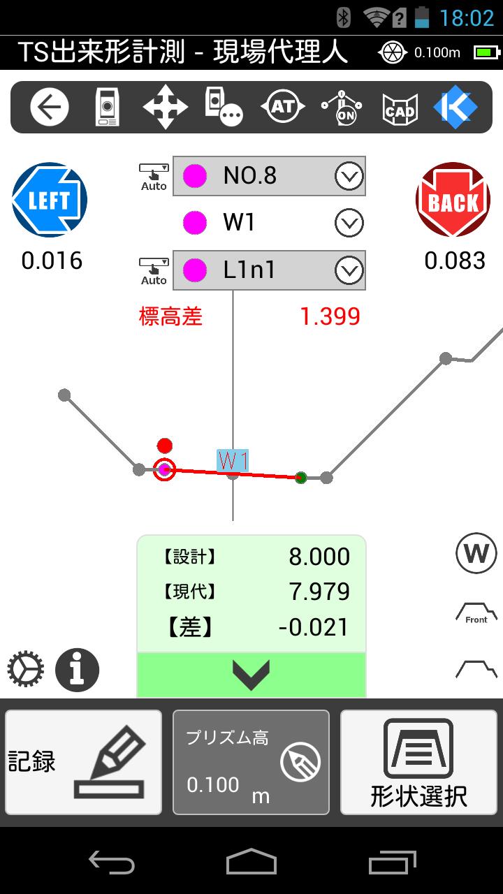
5. TS performance measurement auto mode
Compatible with "finished form management technology using a total station", which is one of the information-based construction technologies! Equipped with the industry's first auto mode that automatically determines measurement points and crossing points. It realizes speedy TS performance measurement with revolutionary functions that are significantly different from conventional methods.
6. Surface construction/surface management
In addition to Dokodoko Navi, you can also use "Surface Finished Form" (TS Rover Observation, TS Rover Inspection, Non-Prescan), which supports surface construction/surface management checks and on-site inspections that are essential for i-Construction, and "Anywhere Surface". We support. You can check the heat map while measuring, and it is possible to understand the difference (altitude, horizontal, vertical), standard value, and workmanship on the spot.
Innovative features that enable rapid on-site work
1. Anywhere Navi/Anywhere Dinghari
Generate and display the cross-sectional shape of the current position in real time. The elevation difference from the plan is always displayed, allowing real-time navigation to crossing points such as structures. Realizes rapid on-site work. In addition, the calculations necessary for setting up a tatami can be performed in real time, so you can install a tatami anywhere.
2. CAD drawing arrangement + CAD View
You can check the CAD drawings in the background during staking and observation, making work easier and more efficient. When staking out, you can move while checking the current location using CAD data. You can also view other CAD drawings such as cross-sectional views.
3. CAD stake out
You can perform site work by simply tapping the point you want to stake out or check (end point, intersection, center point, point, line point, midpoint) based on the CAD drawing.
4. Line installation/observation
You can stake out points that divide the set line or offset points to the left and right. You can also observe the distance between your current position and the line.
5. Four induction steps
Equipped with four guiding step modes that allow anyone to go to the staking point intuitively. The screen display automatically switches depending on the distance to the staking point, allowing for smooth staking work.
6. TS result measurement/TS result inspection/anywhere result
Equipped with 3 TS finished form functions: ``TS finished form measurement'' observed by the contractor, ``TS finished form inspection'' witnessed by the orderer, and ``Anywhere finished form'' for checking the finished form at any point. Auto mode, which automatically determines the measurement points and crossing points, enables speedy and seamless measurements.
7. Surface finished shape
Equipped with three observation functions compatible with i-Construction. "TS Rover Observation" and "Non-Prescan" measure 3D design data using a prism or non-prism for each specified grid size. A heat map is displayed on the spot while measuring. "TS Rover Inspection" also supports on-site inspection of i-Construction.
*3D design data can only be imported as original files in KSS format.
Function list
・On-site management
New site/Delete site/Select site/Import site data/Output site data/New route/Edit route/Delete route/Output coordinate data/Input coordinate data
・Machine installation
Known point setting/Arbitrary point setting/BM measurement/Previous instrument setting/Coordinate setting anywhere
・Stakeout
Coordinate surveying / Route surveying / CAD surveying / Line surveying / Cross-sectional surveying / 3D structure surveying Setting
・Observation
Radiation observation/ Line observation 2D/ Line observation 3D/ Transverse radiation observation (route)/ Level observation/ TS finished form Measurement/ TS finished form inspection/ Anywhere finished form/Surface result (TS rover observation, non-prescan, TS rover inspection)/Kaisoku Scan/Opposite side measurement
・CADView
SFC/ P21/ DWG/ DXF
・Smart construction
Anywhere navigation / Anywhere structures / Anywhere floor excavation / Anywhere slope / Anywhere Surface (anywhere Surface, anywhere slice)/ Anywhere Ding Observation, coordinate point observation, Surface editor, Surface guidance, elevation guidance, reference line editor, guidance construction)/ KENTEM-CONNECT
*Bold red text is a function that can only be used in the Adv (advanced) version.
Operating environment
Please check the construction system homepage for the latest and detailed operating environment
https://www.kentem.jp/product-service/ksnavi/requirement/
Last updated on Feb 8, 2024
新機能
・【Std版/Adv版 共通】現況のSurfaceデータをどこでも丁張等で現況横断線として表示する機能を搭載
・【Adv版】どこでも丁張で測点ロックした際に、断面離れをわかりやすく作業者に知らせるように改良
・【Std版/Adv版 共通】快測ナビデータパッケージを取り込んだ際にしきい値の値も連携するように対応
・【Std版/Adv版 共通】KSデータバンクからファイルを取り込むときに、ローカルストレージにファイルをダウンロードする機能を搭載
修正
・【Std版/Adv版 共通】FOCUS35/50にて、通信が不安定な環境において記録時にエラーが出ることがある不具合を修正
・【Std版/Adv版 共通】横断放射観測(路線)で折れ点の測点において、横断方向が折れ点の半角にならない場合がある不具合を修正
※詳細は弊社ホームページでも確認できます。
https://verup.kentem.jp/ksnavi/20231219/
Latest Version
![]() 6.97.00.20231215
6.97.00.20231215
Uploaded by
Xuân Khu Lò
Requires Android
Android 5.0+
Available on
![]()
Category
Report


Discover what you want easier, faster and safer.

快測ナビ
現場を快速ナビゲーション6.97.00.20231215 by KENSETSU SYSTEM Co.Ltd.
Feb 8, 2024