Use APKPure App
Get Tracklia old version APK for Android
View, edit, create, import, export, navigate, merge, record GPX, KML, KMZ files
TRACKLIA will make your GPX and KML/KMZ mapping work easier! Plan new trips, edit previous, record new and share with the world!
WORK WITH GPX, KML and KMZ files
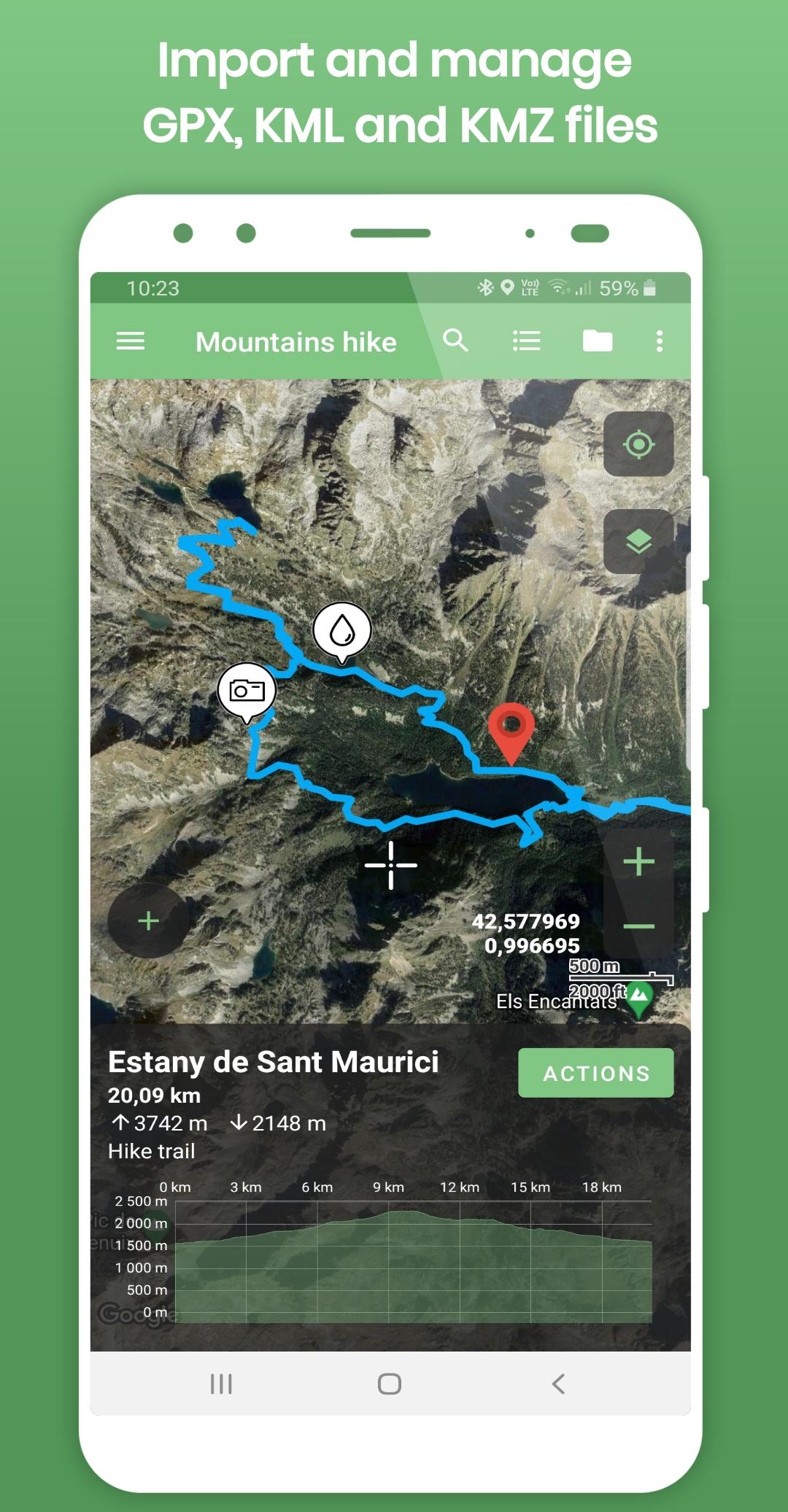
- Import tracks, routes and waypoints from GPX, KML and KMZ files (you can select what to import from your GPX / KML / KMZ file, no need to import everything)
- Record your own GPS tracks
- Get elevation graph, distance and ascent/descent of imported tracks and routes
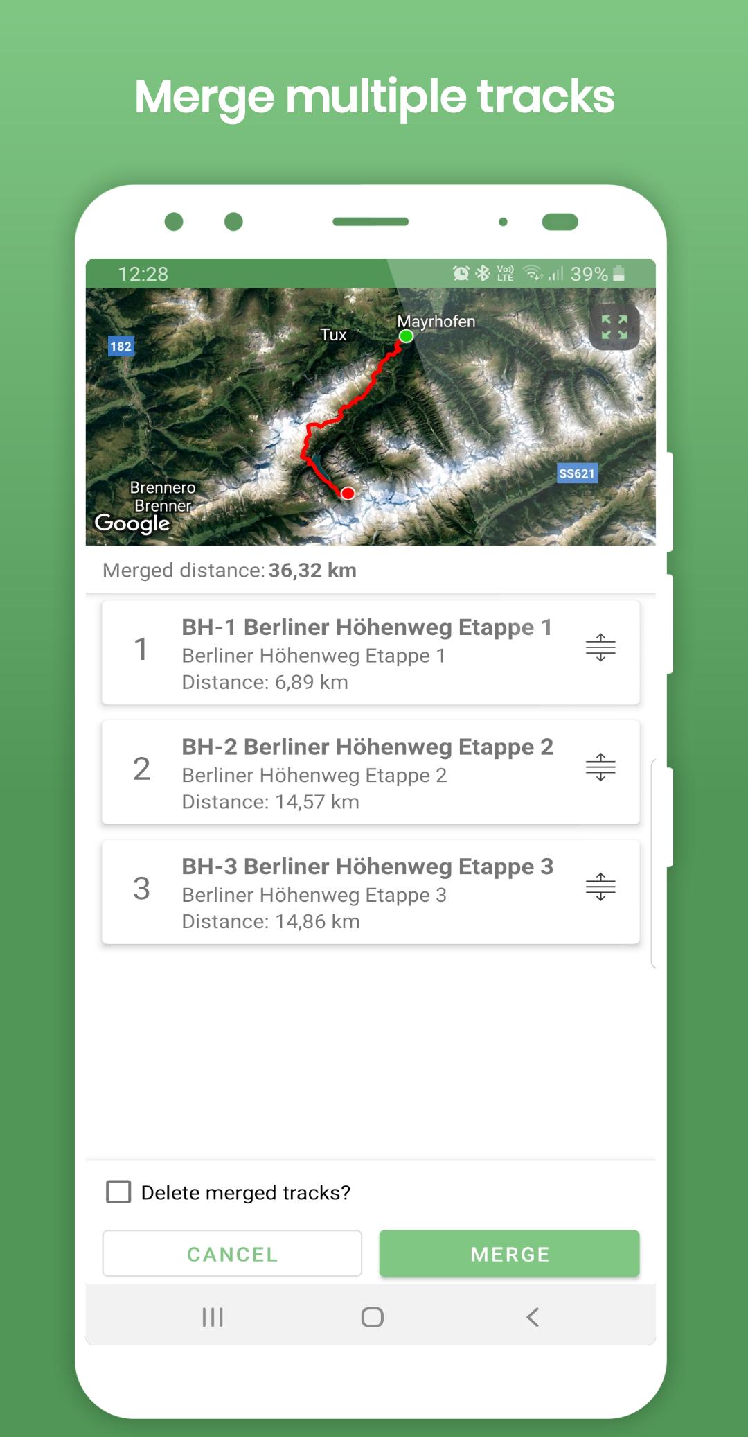
- Merge multiple tracks into one with interactive merger! Useful for Strava, Endomondo and other sport trackers users!
- Split one long track into parts
- Reverse track
- Share tracks and waypoints directly to the other apps (Like Google Maps or other navigation apps)
- GPX, KML and KMZ files edit:
- Add / update / delete / insert points in tracks and routes
- Delete multiple points at once
- Rename / change description for tracks and routes
- Delete tracks and waypoints from GPX, KML and KMZ file
- Update waypoints location, name and description
- Change waypoint icons
- GPX and KML files create / update :
- Create new track
- Add new waypoint
- Export updated or newly created tracks, routes and waypoints to *GPX* or *KML* file
- Export track or route data to *CSV file*
- Draw on map with your finger tip and send as an image.
MANAGE GPX DATA
TRACKLIA lets you to group and store your GPX, KML and KMZ data in app memory (My Maps list function).
You can import several GPX, KML or KMZ files to one map, edit and have it for your next trip! And the best - you can share your created trip with your friends as GPX or KML file!
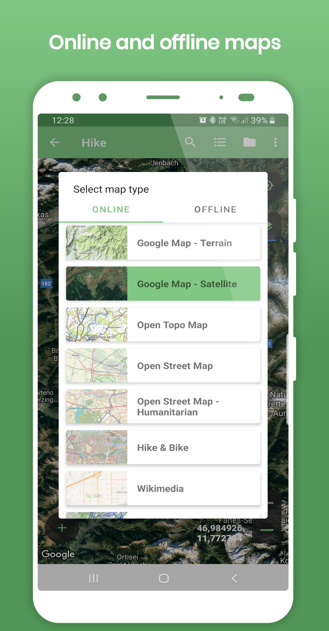
VARIETY OF MAPS
Offline maps:
- Open Street Map
Online maps:
- Google Maps - Normal
- Google Maps - Terrain
- Google Maps - Satellite
- Open Street Map
- Open Street Map - Humanitarian
- Open Topo Map
- Hike & Bike
- Wikimedia
- CyclOSM
- Stamen - Terrain
- Stamen - Toner
- Esri - Aerial
And many more to come!
NAVIGATE YOUR TRIP
- Show current GPS position on map
- Follow GPS position continuously by adjusting map position
- Rotate map according GPS bearing
- See GPS position details (coordinates, accuracy, altitude, speed)
- Use offline maps while navigating
With these functions, TRACKLIA can be used as simple navigation tool.
Languages:
- Deutsch
- English
- Español
- Français
- हिन्दी
- Indonesia
- Português
- Русский
- Türkçe
- Tiếng Việt
If you are looking for tool to import GPX, KML or KMZ files, get GPS stats, edit GPX / KML / KMZ files, create GPX or KML files, update GPX / KML / KMZ files or simple navigation - TRACKLIA is for you!
If you have any questions, suggestions or if you want to help us to translate this app into more languages, please contact us via e-mail tracklia.app@gmail.com or from application menu selecting "Contact us"
Last updated on Dec 25, 2023
- Heart Rate data support in GPX files (import/merge/export)
- Show Heart Rate in track details chart
- Show track start/stop times
- Copy current (map center) coordinates to clipboard on click
- Improved GPX files export. Added support for additional schemas
Latest Version
![]() 1.17.0
1.17.0
Uploaded by
Ibrahim Dönmez
Requires Android
Android 5.0+
Available on
![]()
Category
Report


Discover what you want easier, faster and safer.

Tracklia
GPX, KML, KMZ & maps1.17.0 by Tracklia Inc.
Dec 25, 2023