Use APKPure App
Get Singapore MRT Map Route old version APK for Android
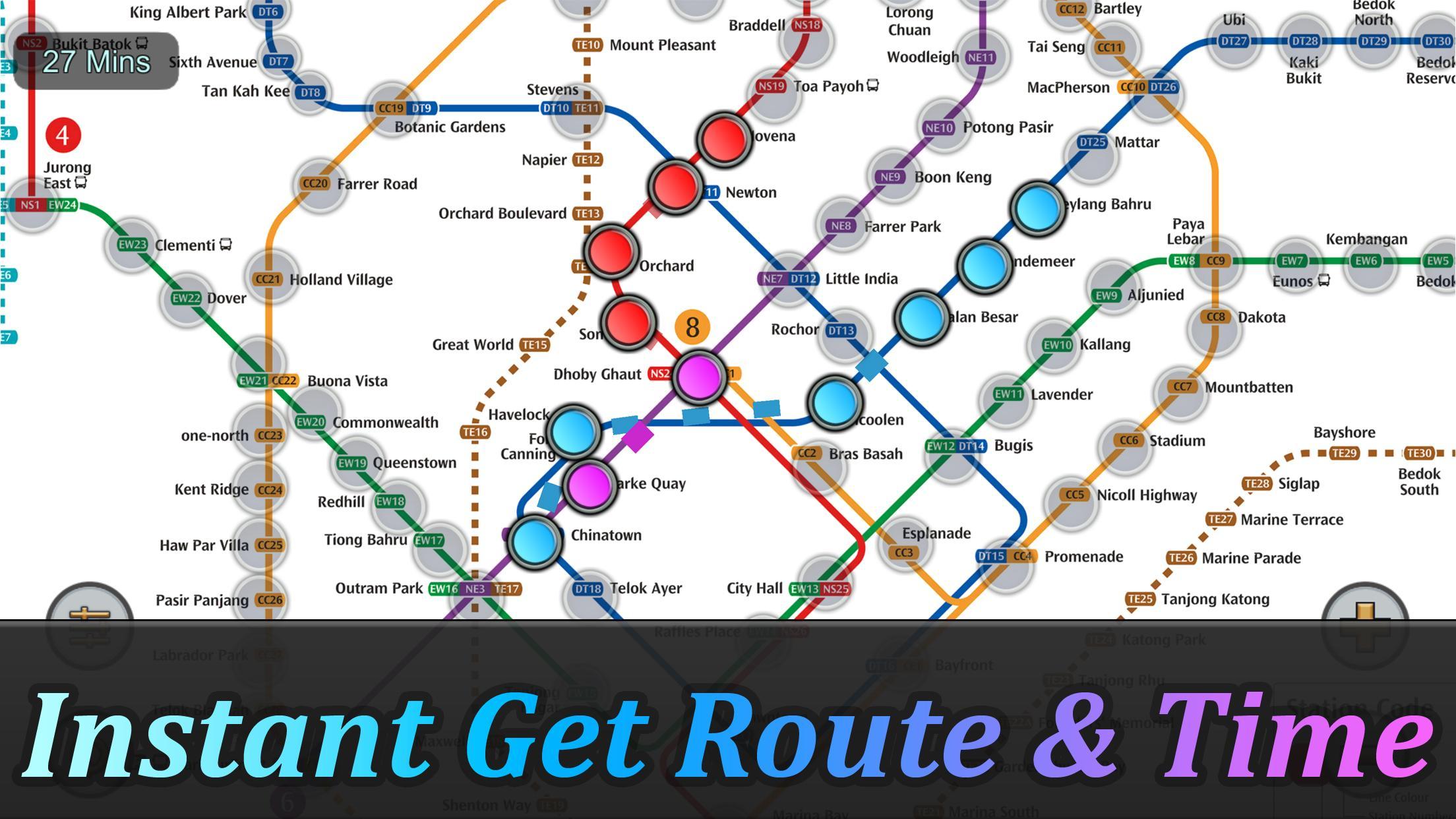
Obtenez l'itinéraire et l'heure les plus rapides en une seconde.
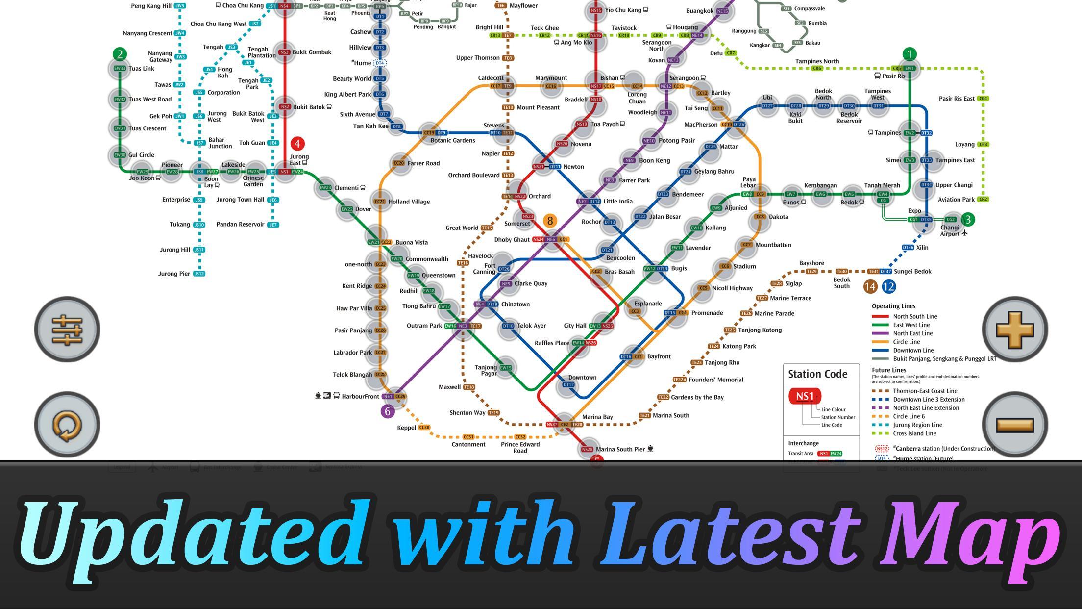
Le système MRT de Singapour s'étend. D'ici 2030, le système MRT sera plus complexe que vous ne pourriez imaginer. C'est bon pour tous les résidents de notre charmante île. Mais ce sera également un problème parce que nous ne savons pas comment voyager le plus rapidement lors du transfert des stations.
Singapore MRT Map Route est conçu pour permettre à l'utilisateur d'obtenir la meilleure route dans une seconde. Cela vous aidera à économiser beaucoup de temps pendant des années.
- Voir la dernière carte de Singapour MRT
- Afficher la meilleure route entre deux stations
- Calculer automatiquement le temps de déplacement estimé
- Ne nécessite aucune connexion Internet.
Mise à jour au dernier système MRT:
Ligne du centre-ville (bleu)
Bukit Panjang, Noix de Cajou, Hillview, Beauty World, King Albert Park, Sixième Avenue, Tan Kah Kee, Botanic Gardens, Stevens, Newton, Little India, Rochor, Bugis, Promenade, Bayfront, Downtown, Telok Ayer, Chinatown
Circle Line (Jaune)
Dhoby Ghaut, Bras Basah, Esplanade, Promenade, Nicoll Highway [C], Stade, Mountbatten, Dakota, Paya Lebar, MacPherson, Tai Seng, Bartley, Serangoon, Lorong Chuan, Bishan, Marymount, Caldecott, Botanic Gardens, Farrer Road, Hollande Village. Buona Vista, un-nord, Kent Ridge, Haw Par Villa, Pasir Panjang, Labrador Park, Telok Blangah, HarbourFront
East West Line (vert)
Pasir Ris, Tampines, Simei, Tanah Merah, Bedok, Kembangan, Eunos, Paya Lebar, Aljunied, Kallang, Lavender, Bugis, Hôtel de Ville, Raffles Place, Tanjong Pagar, Outram Park, Tiong Bahru, Redhill, Queenstown, Commonwealth, Buona Vista , Dover, Clementi, Jurong East, Jardin chinois, Lakeside, Boon Lay, Pioneer, Joo Koon, Expo,
l'aéroport de Changi
North South Line (Rouge)
Jurong East, Bukit Batok, Bukit Gombak, Choa Chu Kang, Yew Tee, Kranji, Marsiling, Woodlands, Amirauté, Sembawang, Canberra, Yishun, Khatib, Yio Chu Kang, Ang Mo Kio, Bishan, Braddell, Toa Payoh, Novena, Newton , Orchard, Somerset, Dhoby Ghaut, Hôtel de Ville, Raffles Place, Marina Bay, Marina South Pier
Ligne Nord Est (Violet)
HarbourFront, Outram Park, Chinatown, Clarke Quay, Dhoby Ghaut, Little India, Farrer Park, Boon Keng, Potong Pasir, Woodleigh, Serangoon, Kovan, Hougang, Buangkok, Sengkang, Punggol
Last updated on Jul 10, 2023
- Added Thomson-East Coast Line (TE1 Woodlands North to Orchard) to the subway system.
- Optimized calculation speed to improve the overall performance of the application.
- Fixed known issues and bugs to enhance the stability and reliability of the application.
Dernière version
![]() 2.4.5
2.4.5
Telechargé par
Matas Klimisauskas
Nécessite Android
Android 5.1+
Available on
![]()
Catégories
Signaler


Discover what you want easier, faster and safer.

Singapore MRT Map Route
2.4.5 by momoStorm Entertainment
Jul 10, 2023